- Working at KSC
- NASA Old Headquarters building on KSC destroyed.
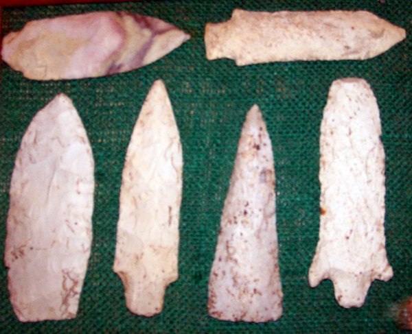
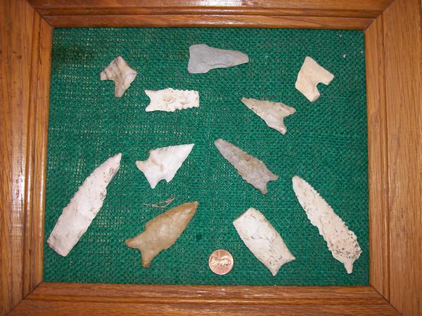
- Flintknapping points
- Vampires of Kennedy Space Center and the O&C
- Demons of Kennedy Space Center
- Demons of Kennedy Space Center, corpus callosotomy
- Ghosts of Kennedy Space Center, End of Spiders
- Dreams of Kennedy Space Center, lovers and pyramids.
- Witches of Kennedy Space Center
- Cave Bears of Kennedy Space Center
- Aliens of Kennedy Space Center, uninvited guests
- Remembering Kennedy Space Center
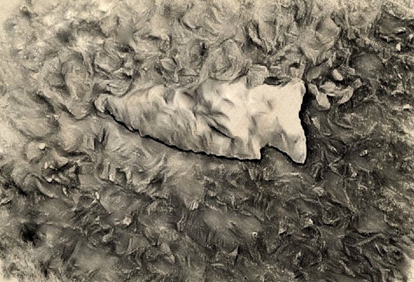
- Lake 33 Killing Relic
The O'Day Park, eastern Missouri and the bulldozed Native American Artifacts.
Don't get me wrong-I love the O'Day park! Green space!-Not the unrelenting developments that blight the entire nation. And I'm not footing the bill for the park, that would be the gullible O'Fallon Tax Payers.
I don't actually believe the ever expanding, ever taxing (and spending) City of O’Fallon or their parks department actually knew about the artifacts under the torn up earth and the construction equipment.
Because the land around O' Day Park has lain fallow since the Pipeline fuel spill. So why would they- why would they know?
Sort of sad: In Florida, the laws on human remains are so strict that many contractors just cover up any discovered remains as quickly as possible to prevent costly expensive delays. How much information is lost?
However at the O'Day Park in St. Charles County Missouri; I truly believe no one knew about the artifacts, bones or the teeth.
However my first eighteen years of life were spent in those fertile fields. And I have memorized the location of every flake cluster, arrow point or unique items discovered. We had no internet in those days.... So my brothers and I "observed" what ever caught our eye- be it animal or artifact.
Found on O'Day Creek ridge
When you spend other peoples money, you have to make them feel good about it....
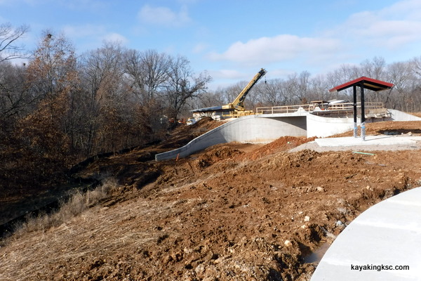
Over the winter vacation, during a survey trip for the upcoming MR340 kayak race I did a quick trip up the ridge to see if any artifacts had been exposed by the heavy equipment. I was disappointed how the soil had been shifted around burying any artifacts. But also that two massive man made hills had been created for the City's new playground. Such is life.
The new hills did change the water drainage (onto us) as well as their playground dumps water onto our property that kills old growth oak. Details at my Assaulted by O'Fallon page.
Growing up in the O'Day Valley.....
Growing up on the O'Day Creek, (in the time before the internet) -no matter the season, riding or walking the fields of the O'Day valley was a prime pastime.
O'Day Creek under the trees
It was not difficult to locate the Native American sites--the brown dirt would glitter with shards of flint after a rain shower & arrowheads would appear in the dirt and in the rocky O'Day Creek.
There was even competition with my brother to see who could get up earliest and get to what we called Indian Teeth Ridge.
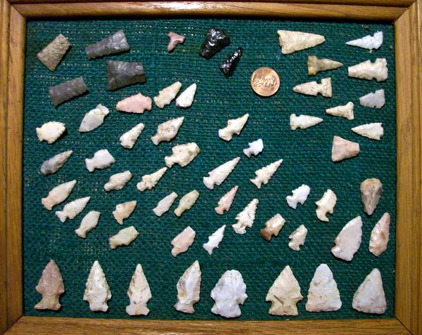
Arrow points found on Indian Teeth Ridge (playground area of the new O'Day Park)
--except for the two obsidian arrow points I found in Nevada while in the USAF
Assumption: I always assumed the Scalorn bird points (rounded serrated arrowheads were related to the Missouri and Osage nations because of cultural affiliation with the southern plains & short grass parries. Scalorn points are found as far south as the Caddo Indian nations.
While the triangle shaped Mississippian cultural arrow points-including the Cahokia side notched arrow points were more related to Illini peoples who inhabited the River Bottoms. of the Missouri, Illinois and Mississippi River basins.
Assumptions however can be wrong. Heck I think I'm wrong most of the time.
The O'Days
I was first told about the O'Day homestead, by Ambrose Schulte, who grew up in the area (his family's farm was the current site of Lake #33 in Busch Wildlife Area and was confiscated by the United States Government via Eminent Domain just before WWII)
As a kid I was memorized by Ambrose's stories of Dardenne Creek and the O'Day Branch Creek prior to the Weldon Springs TNT plant.
Ambrose who in the 1930's would ride his horse to school at the Dardenne Church- traversed the gravel road that is today is the entrance to the new O'Day Park. (There was no Highway DD in those days.)
He described the abandoned "haunted" Frazier Farm on the opposite ridge of the park and the Frasier-O'Day cemetery that had a rusting iron fence around the grave stones. (as a child I was always fascinated by the oldest grave stone in that cemetery: 1721)
Chert blades from the O'Day Ridge
(The rest now lie beneath the clay-dirt of the O'Day Park playground currently under construction)
When I showed Ambrose a handful of broken Indian pottery he told me how the O'Day family had leveled an Indian mound on the field below Indian teeth ridge. (This field on the O'Day flood plain is now overgrown with twenty year old cedar trees)
One season in this old mound field, I also found a scrap of leather harness in the plowed earth. The ancient leather was embossed with a brass button and the raised letters "U.S." -my excited over active imagination-assumption was that the button was from the Civil War.
Perhaps you have heard of "The War of Northern Aggression" however Ambrose had explained that after World War One, the Army sold it's leather artillery horse harness to all the farmers as military surplus.
"Before World War Two, most people could not afford the new motorized tractors and plowed by horse or mule" explained Ambrose.
The button was still pretty cool.
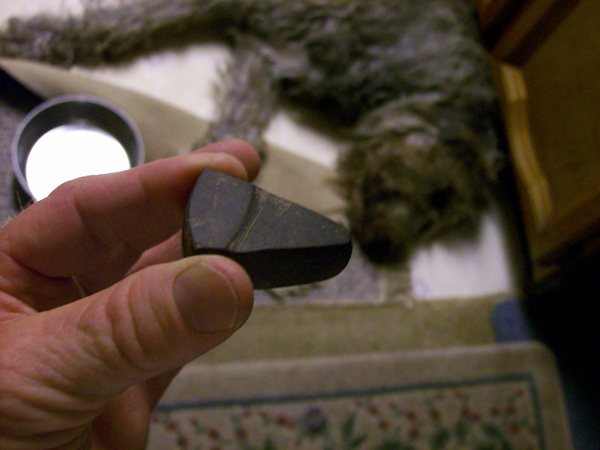
One of the oddest Native American artifacts I found on O'Day ridge. A triangle of smooth hematite. To this day I have no idea what it was used for. Making paint?
New park under construction on Indian Teeth Ridge
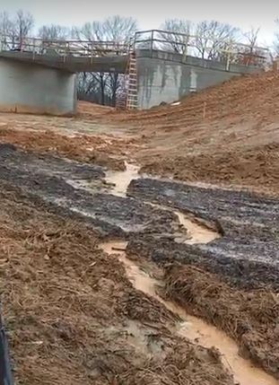
Silt run off caused by the new park
Indian Teeth Ridge.....
Indian Teeth Ridge where did that name come from?
At one time we called the high field above the O'Day Creek "Arrowhead Hill" - However around 1970-ish the pipeline company replaced the dual pipelines across the O'Day.
I recall the pipelines had been exposed to frost and flood and we often used the pipes as a walk bridge over the shallow rocky creek.
For some reason the pipelines were replaced up the side of the O'Day ridge and into "Arrowhead Hill"
The clearing of that ridge created a dare devil horse back riding trail-far too steep for safe equestrian activities; however as fearless kids and then teenagers- the trail was an irresistible cure for both boredom and then showing off riding skills to the local girls. (The poor horses-luckily we were all skinny and exceptional riders and so there was never an injury to horse or rider "on that trail anyway")
Parents would have been horrified and perhaps even a belt brought out if they knew we were riding up and down that hill.
Back to The name Indian Teeth Ridge.
The following spring after the pipeline replacement when the fields were plowed again-old rotten bones appeared in the fresh turned soil.
The bones themselves all turned to powder in short order however human teeth turned up in the field year after year until plowing ceased forever around the time of the final pipeline leak.
Even though flint chips and arrowheads appeared across the entire field & down the horse back trail and the pot shard field; the human teeth were centered around the pipeline excavation at the peak of the ridge.
I often wondered how deep the pipeline equipment had excavated to find bones.
To be honest it had been decades since I had thought about the teeth in that fertile field until the quick walk to see the new park and the turned up soil.
The Persimmon Grove.....
Why the plethora of artifacts in the O'Day valley? I can only speculate. (make assumptions)
Of course in Missouri any high location above water has artifact assemblages. And the O'Day is no different than the rest of the state.
And a spring helps.....In the O'Day Creek at the base of one of the new park overlooks "there used to be" a all year round spring.
The spring finally stopped flowing as more homes tapped into the aquifer (my family's well included)
However besides springs and fertile fields, I believe the real draw for both animal and man was the giant persimmon grove that once existed where the Rolling Meadows development now blights the land.
This massive grove of persimmon trees that once spread across the entire modern development would have been the equivalent of a pre-historic Walmart and would have provided food for months. (I was so mad when the Persimmons trees were bulldozed- might be another reason I was ecstatic to learn of the O'Day Park proposal)
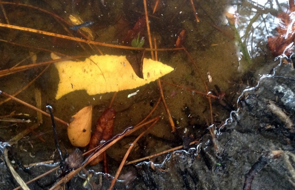
Spear or dart point in an O'Day Creek gulley
It was no coincidence that the Frazier homestead that once stood on the best view of the O'Day Valley had been constructed with the persimmon tree grove as the back yard-ready made food for hogs or wine making if one was so inclined.
As mentioned the developer for Rolling Meadow came in and bulldozed the ancient grove that had probably existed in that location since the time when the glaciers retreated.
Want to find the remains of the Frazier homestead? Walk to the southern boundary of Rolling Meadows and peer into the forest.
When growing up in the O'Day valley the rocky remains of the homestead were close cropped by cattle and more than one tiny arrow point was discovered on the cattle trails.
Conclusion: End of rambling thoughts..... Hobbies and Eminent Domain
Growing up in the O'Day Valley was the formative building block of my adult hobbies and interests that followed me to humid Florida. -A fascination with history.
And walking the fields of Busch Wildlife Area with Ambrose Schulte as he pointed out his own boyhood memories heightened my disgust at the Federal or State land grab called Eminent Domain.
And so when being assigned to Cape Canaveral in the Air Force and then working on NASA's Kennedy Space Center, once again I was immersed in both the history of east Florida and the unjust land theft that created both "The Cape" and Augusta A. Busch Wildlife Area.
The results of both areas are spectacular but were they worth the cost? Same could be asked about the new O'Day Park- "I assume."
O'Day Creek finds:
Found in random non-context gravel bars but hinting to a history stretching back to the time of the glaciers.
A couple of my books (fiction) about the Weldon Spring-Dardenne Area.
Return Home from O'Day Park Native American artifacts page.

My next book!! "Surviving Kennedy Space Center"
on Amazon.
Peek behind the curtains of the Shuttle and Artemis programs.

(Second to newest) My newest book, available on Amazon
(paperback and e-book)
For pet lovers around the globe, "It's a Matter of Luck" is a collection of heart warming stories of horse rescues from the slaughterhouse.
Available on Amazon

It's a Matter of Luck: Inspirational, Heartfelt Stories of Horses Given a Second Chance.
by Kim Ryba & Lina T. Lindgren
Warning: This book may cause your eyes to water in a good way. (speaking from experience after reading it)
Please give Kim and Lina a heartfelt review on Amazon!

Author Bruce Ryba at Kennedy Space Center Launch Pad 39B & Artemis 1. "We are going to the Moon!"
Author's discussion (that's me) on You Tube of a book review on Amazon
For the video versions of information, please check out my YouTube Channel (Turkeys, Flintknapping, dive stories etc.)
My fictional series/stories on Florida history:
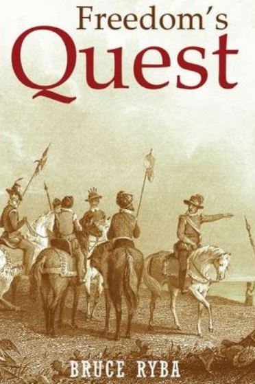
Freedoms Quest (book one)
Struggle for the northern frontier and other lost tales of old Florida.
Available on Amazon

Desperate times call for bold action.
In a desperate move to retain Florida and protect the treasure-laden galleons on their dangerous return journey to Europe, the King of Spain issues a royal decree offering refuge to all English slaves who escape Florida and pick up a musket to defend the coquina walls of Saint Augustine.
In another bold gamble, the King offers refuge to the dissatisfied Indian nations of the southeast who will take up arms against the English.
Clans, traumatized by war and disease, cross the Spanish Frontier to settle the cattle-rich land and burned missions of Florida.
Follow the descendants of the conquistador Louis Castillo in remote Spanish Florida, a wild and swept by diseases, hurricanes, and northern invasions.
Book Two: End of Empire Available on Amazon!