- Working at KSC
- NASA Old Headquarters building on KSC destroyed.
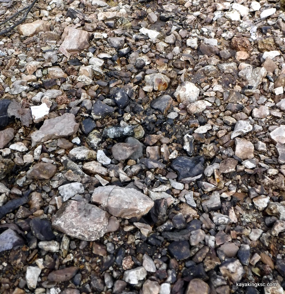
- Flintknapping points
- Vampires of Kennedy Space Center and the O&C
- Demons of Kennedy Space Center
- Demons of Kennedy Space Center, corpus callosotomy
- Ghosts of Kennedy Space Center, End of Spiders
- Dreams of Kennedy Space Center, lovers and pyramids.
- Witches of Kennedy Space Center
- Cave Bears of Kennedy Space Center
- Aliens of Kennedy Space Center, uninvited guests
- Remembering Kennedy Space Center
- Lake 33 Killing Relic
O'Day Park and new housing Turmoil
More disruption of lives caused by the Empire of the City of O'Fallon.
An apology. I had to take a two year forced break from this site. Work at the space center was consuming all of my time.
Then in the spring the space center shut it's doors because of COVID-19. Forced overtime ended. (for a little while anyway)
They sent me home with a laptop to keep working.
I was sort of in shock.
Not because of the virus, or the laptop. But because I had been working 'off and on' a mandatory 60 work week for almost two years straight.
Onset of the pandemic and I was returned to 40 hours a week with weekends off!
City of O'Fallon Turmoil
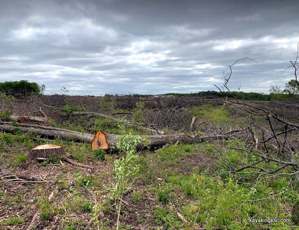
Do you see the missing forest?
This is now the "Streets of Caledonia"
Over the summer and the previous winter I have been inundated with information and complaints about both the O'Day Park and the cutting of the last green space at the end of Highway DD. (The City bragged about their paved green park but let the wildlife and hiking corridor be bulldozed for six hundred homes)
To be fair. The Mayor of O'Fallon has bragged it is their goal to develop everything until out of land in 2040. So why be surprised?
Bats....
Some people were furious about the habitat destruction for the endangered Indiana Bat.
To be truthful most people do not care or know about the plight of the bats.
However I was sent photo after photo of the old growth oaks cut down. Goes without saying, the clear cutting of the last wildlife green space corridor on the eastern end of Highway DD for the new Caledonia development upset some people
Most travelers of the Highway DD are still blissfully ignorant of the new traffic circle that will bring the traffic speeds to, well a little faster than a snail.
I have been flooded with photos of the watershed development on the O'Day Branch Creek. Once again a failure by the Missouri Department of Conservation and MoDNR
While I have come to expect on lip service and inaction from both the Department of Conservation and DNR after they willfully botched the pipeline leak on the O'Day Creek, I did believe the Conservation Department would have attempted some effort because the mud and silt from the ecological disaster known as Caledonia flows directly into Bush Wildlife Area.
So I will touch on the most important items brought to my attention, all related to the turmoil from the park and developers.
Park patrons and conflict with neighbors.
Pipeline fuel again in the O'Day Branch.
Clear cutting of the Enchanted Forest and the Pioneer Cemetery.
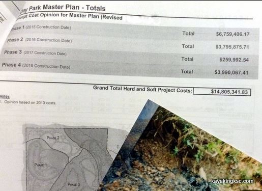
O'Day Park, the $Seven million (so far) crown jewel of the tax and spend Colonial Empire known to some as the City of O'Fallon.
I did a quick tour of the park this past winter. Impressive park (as well it should be for the gouging of the clueless O'Fallon Tax payer)
Seven Million dollars? And the 55 acres of land was provided to the City for free. (To be fair, I stand corrected. It was 57 free acres)
To be fair.
The Good
First thing I noticed? The deadly entrance and exit. It had been modified slightly. Turning lanes had been added. Adequate? No but it was a gesture that should be acknowledged.
Sometimes pointing out the death trap gets someone's attention. My relatives live on that road. So letters to the Missouri Department of Transportation. Of course, the good folks who did bother to respond assured me nothing was wrong.
Letter (Note: the Missouri Coalition for Roadway Safety completely ignored me. They have great propaganda though!)
And of course my page Malfeasance of the Missouri Department of Transportation put them on notice they would be liable for the coming highway fatalities.
Failure to act, constituted the Actus Reus of a crime that could have been avoided. Sadly on Highway DD that crime will be vehicular homicide
Ok, so I covered the "Good"
On to the ........not good.
Park patrons and conflict with neighbors.
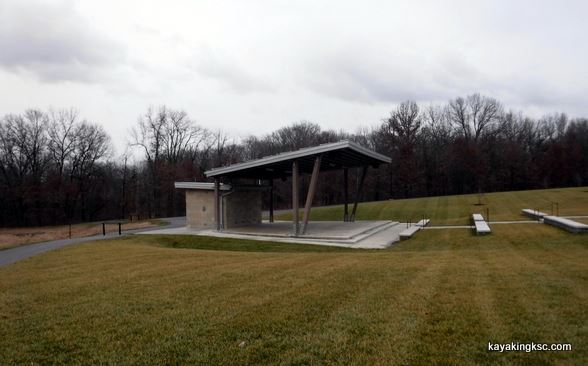
O'Day Park open air amphitheater.
Live music, all the rowdy fun that goes along with celebration and Dionysus, however....
As expected.
As warned.
The park concerts attracts more people than there is parking. The overflow of vehicles results in parking outside the O'Day park.
Parking Anywhere they can. Streets, roads, paddocks and pastures. Of course in yards. There have been arguments bordering on assault between property owners and park patrons.
Hey no one wants to make the 1.5 mile hike around Oak Drive to the park entrance when they can simply walk through someone's back yard.
The predictable result: Noise, trash, peeing in the flowers and smashing of fences. And that is on the trek into the concerts.
Apparently when the music ceases for the evening; it is a free for all on the way out to the trespassing vehicles.
A literal flood of drunks laughing, cursing, fighting. Threats to neighbors and pets. A swim in the lake. Even an attempt of one inebriated person to ride a horse bareback. Not their own horse of course. (In short, it sounds fun as hell.)
And a carpet of trash is laid from the band to the illegally parked vehicles. While inside the park proper, (feet from peoples homes the celebrating park patrons are free to celebrate, yell, hold impromptu tailgate parties until they decide to turn onto Highway DD from the almost blind park entry/exit.
Of course for the park patrons and park employees, it is not their rural lifestyle that has been shattered.
As far as the O'Fallon City Council is concerned those residents living around the edges of the park "Are outside of the City Limits and are of no concern" The residents have no right to speak at the Empire of O'Fallon city meetings.
They cannot, they are not allowed to complain that their rural lifestyle is disrupted every weekend. No concern to the city.
Of course that is just one reason for the O'Day Park Lawsuits against the City of O'Fallon.
As I said all along, the City will eventually use the "prairie" paid for by a grant from the Missouri Department of Conservation as parking overflow. If you are a corrupt politician, it does not get any better.
Pipeline fuel again in the O'Day Branch.
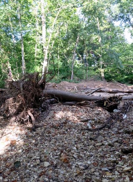
Destruction of the O'Day Creek from flooding caused by the O'Day Park parking lots, land clearing and paving of the bluff along O'Day Creek.
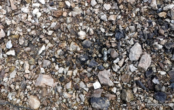
Notice the disturbed gravel beds from the increased flooding?
(just ignore the tore up trees and erosion, I'm talking about black gold!)
Actually the Pipeline fuel resting down stream in the HWY DD bridge area (photo above) was never cleaned/recovered or gravel remediated.
Never
The Conservation Department never complained and the MoDNR and oil company were more than glad to walk away from the dead zone.
(That area of O'Day Park and Busch Wildlife area was only dead for about 12-13 years)
Almost makes sense not to make them clean up the Missouri version of a Valdez oil spill. Luckily no one tossed a match in the water.
For perspective:
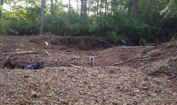
A photo with Pete the dog standing in the O'Day Creek this past spring. A good example of the erosion after the O'Day Park paving and clearing changed the watershed.

The O'Day Creek now. (photo above)
Pete is standing in the disater caused by the park
Videos of flooding caused by the Park
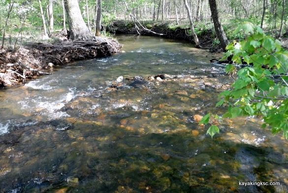
The O'Day Creek before the massive erosion caused the park.
So this past winter I inspected the O'Day Creek to review the erosion. Every since the O'Day Park cleared and asphalted their parking lot area, the speed of the water flow has nearly doubled.
The chocolate turbidity of the stream is the new normal. (Conservation Department no where to be found)
The new erosion damage is stunning as it is sad. (And my inspection was performed just before the Caledonia development cleared 90% of the forested hills along the O'Day Creek during the late winter/spring of 2020)
The pipeline leak and hence the origin of the bizarre property shape of the O'Day Park (look it up!) and the fish kills originated when the Conoco Pipeline leaked approximately 70,000 gallons of petroleum product into the O'Day Creek.
Conoco & an EPA inspector were on site the next day, (cutting our fences) and recovered just under 1000 gallons (the amount of their admitted spill report to the Office of Pipeline Safety)
The origins of a "1000" gallon spill can be found on the pipeline web page.
Stop.
I often ridicule the symbiotic and incestuous relationship between the City of O'Fallon overlords and the builders/land developers. And of course ridicule the sheep that follow blindly along. I am one of the sheep. And come on, this pattern of corruption has been going on since Roman times. Abuse is normal business.
However no one in our family was prepared for the powerful and cocky Cabal of the oil companies, DNR, EPA, Department of Conservation and State Government. I will not go as far as to call it evil. -Let me think on that.
What am I getting at? The Petroleum Product that is still in the O'Day Creek in the area of the Highway DD bridge and wildlife area.
Fuel stained gravels from the pipeline leak exposed by the new increased water speed and shifting of gravel beds.
Photo taken Dec. 2019
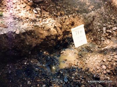
Compare the Dec 2019 (above) photo with this photo of a contaminated gravel bar that was removed by the oil company. (40 truck loads of black gooey gravel removed) BUT NOT ONE ROCK removed on the O'Day section of the creek by the HWY DD bridge.
Return to my erosion inspection this past winter and review of the damage the O'Day Creek.
About a 100 paces upstream of the Highway DD Bridge, there was the exposed petroleum stained gravel.
Hello Darkness my old friend.
Lets If I can keep this brief.
On our property, because we complained:
The EPA/DNR/DOT forced the oil company to return the O'Day Creek, and perform nine expensive remediation clean ups over a nine+ year time span.
The ninth and final clean up removed "40" dump truck loads of Petroleum stained black gooey gravel.
We were very familiar with the black stained rock.
**Noteworthy that the corrupt MODNR declared the O'Day Clean after the first clean up attempt and the 1000 gallons of product recovered.
**The Department of Conservation hardly blinked an eye at ten years of fish kills. In their defense the Conservation department levied a massive $200.00 dollar fine for the fish kill. Impressive stuff!
**And the EPA Inspector General found nothing wrong. The Office of the Governor of Missouri found nothing wrong.
Of course this page is not about that Cabal.
Evil, maybe
Do things big. Massive Park budget.
Massive contamination in the O'Day Creek
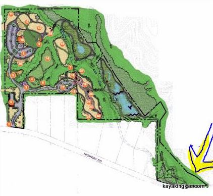
The bizzare shape of O'Day Park.
The Property was carved out to avoid the contaminated areas of the O'Day Creek.
The Yellow arrow points to the area just upstream of Highway DD where DNR, EPA and the state did NOT make the oil company clean their mess. 70,000 gallows of petroleum wait to be exposed. And the yellow arrow also points to where this past winter I found the petroleum stained gravels. I did not have time to record any fish die offs.
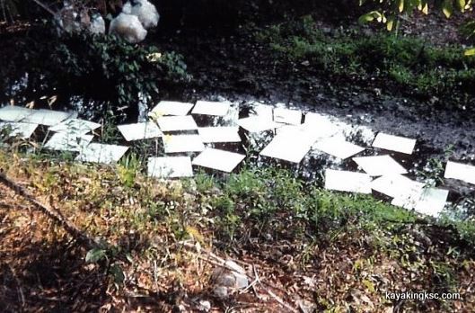
Photo of the FOUTH clean up of the O'Day Creek, two years after the initial spill. (EPA Inspector General : "Nothing to see here")
MoDNR & the oil company were desperate to stick with the "Only1000 gallons leaked narrative" which is why MoDNR claimed the O'Day was clean NINE different times and why we had to go court against Conoco. MoDNR Hated us.
The stretch of creek around Highway DD and Busch Wildlife area was NEVER cleaned.
The petroleum clean ups in in the O'Day Creek were strictly focused on the area of our farm and the pipeline area. Everything down stream of our property and Busch Wildlife Area was not touched.
The Cabal was aware the petroleum was still in the O'Day. The property owner (an investment company) opted to get rid of the contaminated property. They were very aware that the last entity holding the property was responsible for the petroleum remediation in the O'Day.
Hence the City of O'Fallon acquired the 57 acres for one dollar. Hence the bizarre shape of the property.
December 2019 photo.
So there it was. The oil stained gravel exposed by the ravages of the new 'normal' water flow of the O'Day.
Key to remember. 70,000 gallons of petroleum product went somewhere. And that area is the gravel bars around Highway DD.
The new development cut in a sewer line down to and across the O'Day Creek. In the exact area of the petroleum contamination.
By the way. No silt fences. MODNR doing their outstanding "I am owned by the developer routine"
Why expect any changes?
Final two comments on this subject.
The O'Day Park changed the watershed of the west side of the O'Day Creek.
The new Caledonia development (has cleared) & will pave the east side of the O'Day Valley.
What will be exposed & how long will the creek be dead this time?
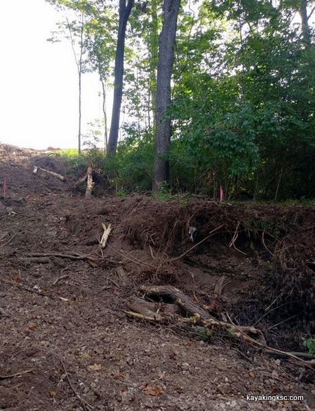
The new Caledonia development buldozers have pushed into the once beautiful O'Day Creek.(Compare with the O'Day creek photo above) As part of their plan to pave the east side of the O'Day Valley.
How long will the creek be dead this time?
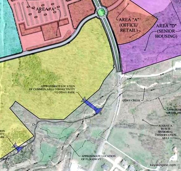
Want to see the petroleum and fish kills in person? It is O'Day Park property after all. Where the purple bar crosses the O'Day Creek, down to the HWY DD bridge and into August A Busch Memorial Conservation Area is the greatest concentration of pipeline product. "The Dead Zone"
The fish kills will return from this massive disruption of the creek and expose the lost petroleum product and flush the proverbial developer toilet into Busch Wildlife Area.
Hello darkness my old friend.
Will the City of O'Fallon be responsible for the remediation?
Will the Department of Conservation finally get involved? (doubt it)
Final comment.
The Original O'Day Park plans were to build structures in this area to slow the water speed of the Creek. (BS story to get a permit to asphalt the west bluffs?) I took note that these structures were to be installed in the final phase of the park & were going to be placed in the O'Day, directly on top of the hidden petroleum product from the pipeline leak.......I was definitely curious to see what bubbled to the surface during that construction.
I said BS story because it does not appear that the structures to slow the water will ever be constructed.
However it was GREAT propaganda and the person(s) who came up with the concept really believed it would slow the water in the creek.
Update: a return to the O'Day Creek on October 9th 2020 and I took photos of surface level petroleum only feet from where the new sewer line was cut in for the new Caledonia development. Sad yes.
Will MoDNR and Missouri Conservation do anything this time?
What was that Jed Clampett song again? The Ballad of Jed Clampett:
Then one day he was shooting for some food,
And up through the ground come a bubbling crude
Clear cutting of the Enchanted Forest and the Pioneer Cemetery.
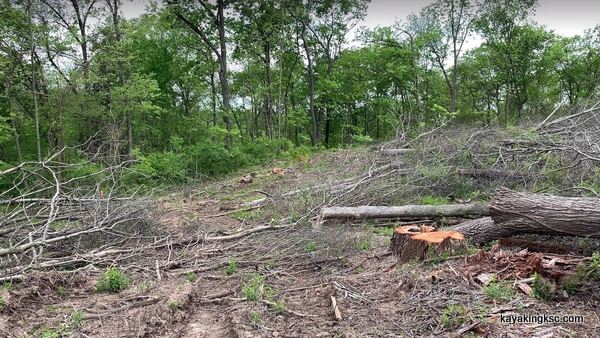
Clear cutting of the Enchanted Forest and the Pioneer Cemetery. As mentioned I get a lot of photo's of the destruction of the forest.
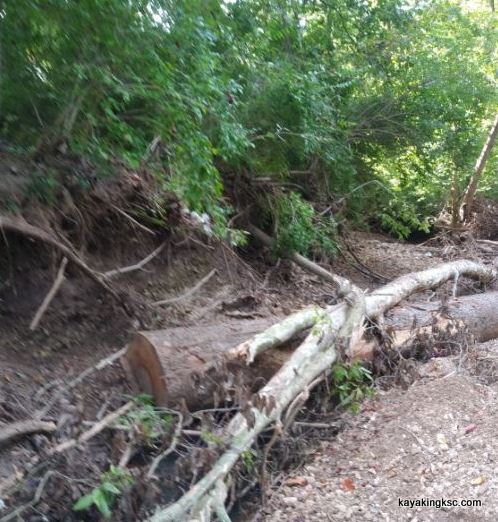
Erosion in the O'Day and, and the old oaks in the O'Day Park right away were logged along with the Enchanted Forest on the bluff.
It is great when everyone is a criminal. Clear cut the forest right to the stream edge. Bastards.
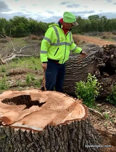
They could not spare this Bee Hive tree?
Bastards
One photo that was particularly sad was a picture of the bee hive hollow oak that had honey bees in the tree since I was a child and now cut down. They could not save the one oak honey bee hive? (There are pretty houses now!)
Another photo shows the feed stream known as the Spring Branch for the sweet tasting water. Both sides of the spring branch were stripped bare and I assume it will be paved over as a drainage canal.
The bee hive destruction was depressing in a time when bees are under assault however I was shocked by the pioneer cemetery destruction.
Pioneer cemetery
I had truly believed they would have kept the little pioneer cemetery as a small plot, a tiny park- or anything other than what they did.
Native American graves are protected. Why isn't the same rights afforded to the burials of the pioneers who settled this area?
On the ridge above the O'Day creek is a pioneer cemetery that at one time had 14 headstones with the family names of the O'Days, Baldridge, Frasier and Callaway. The oldest marked headstone was dated at 1721 and newer dates were the 1860's with the O'Day family headstones.
Around the marked graves were hundreds of field stone markers line up neatly that we believe were the grave sites of African Americans.
The previous property investor officially relocated three of the 14 graves.
The head stones had been vandalized & the investor was only required to move three burials.
Years ago we established there was approximately 100 burials of African Americans in this cemetery and the nine burials that the previous investor refused to acknowledge.
However that was before the invention of GPR. (Ground Penetrating Radar)
"If they had wanted to know" The location of the graves could have been discovered very inexpensively, quickly and accurately and the area made into a small green area-park.
It is all gone now.
I had thought there were cemetery protection laws in Missouri. But then I had once beloved the EPA, DNR and the Department of Conservation were there to protect the environment.
All dummies have to grow up...
So. I wonder. Do the Developers have to explain to prospective home buyers that their house is constructed on a cemetery?

Return Home from O'Day Park Turmoil page

My next book!! "Surviving Kennedy Space Center"
on Amazon.
Peek behind the curtains of the Shuttle and Artemis programs.

(Second to newest) My newest book, available on Amazon
(paperback and e-book)
For pet lovers around the globe, "It's a Matter of Luck" is a collection of heart warming stories of horse rescues from the slaughterhouse.
Available on Amazon

It's a Matter of Luck: Inspirational, Heartfelt Stories of Horses Given a Second Chance.
by Kim Ryba & Lina T. Lindgren
Warning: This book may cause your eyes to water in a good way. (speaking from experience after reading it)
Please give Kim and Lina a heartfelt review on Amazon!

Author Bruce Ryba at Kennedy Space Center Launch Pad 39B & Artemis 1. "We are going to the Moon!"
Author's discussion (that's me) on You Tube of a book review on Amazon
For the video versions of information, please check out my YouTube Channel (Turkeys, Flintknapping, dive stories etc.)
My fictional series/stories on Florida history:
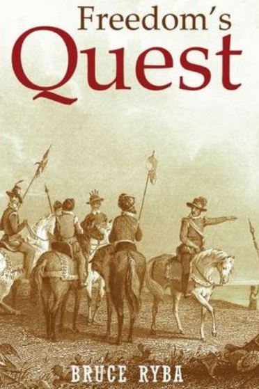
Freedoms Quest (book one)
Struggle for the northern frontier and other lost tales of old Florida.
Available on Amazon

Desperate times call for bold action.
In a desperate move to retain Florida and protect the treasure-laden galleons on their dangerous return journey to Europe, the King of Spain issues a royal decree offering refuge to all English slaves who escape Florida and pick up a musket to defend the coquina walls of Saint Augustine.
In another bold gamble, the King offers refuge to the dissatisfied Indian nations of the southeast who will take up arms against the English.
Clans, traumatized by war and disease, cross the Spanish Frontier to settle the cattle-rich land and burned missions of Florida.
Follow the descendants of the conquistador Louis Castillo in remote Spanish Florida, a wild and swept by diseases, hurricanes, and northern invasions.
Book Two: End of Empire Available on Amazon!