- Working at KSC
- NASA Old Headquarters building on KSC destroyed.
- Flintknapping points
- Vampires of Kennedy Space Center and the O&C
- Demons of Kennedy Space Center
- Demons of Kennedy Space Center, corpus callosotomy
- Ghosts of Kennedy Space Center, End of Spiders
- Dreams of Kennedy Space Center, lovers and pyramids.
- Witches of Kennedy Space Center
- Cave Bears of Kennedy Space Center
- Aliens of Kennedy Space Center, uninvited guests
- Remembering Kennedy Space Center
- Lake 33 Killing Relic
Streets of Caledonia
St. Charles County Missouri
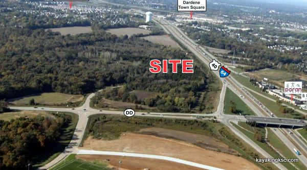
The Largest (last) remaining land tract available for development in the I-64/Hwy 40 Corridor
"Soon" to be the beautiful home to 600 houses
(once the annoying forest is cut out of the way)
There is of course more forest and farms to the west.
However this section of land near the intersection of Highway 64 & Highway DD has been for years locked up in an investor family dispute/war.
Now that the blood has congealed this last bit of green is slated for another housing development.
Have to admit I'm out of step with the times. I just finished reading a St. Louis newspaper article where the mayor of O'Fallon and others were bragging (I'm paraphrasing) "That they would develop ever inch until they ran out of land.....in 2040".
So I say I am out of touch because they uttered those words with apparent pride--While I read the sentence with horror.
The article did provide a fascinating sliding tool that demonstrates the 30 year development of farm and field west O'Fallon and along the Highway 64 corridor.
Fascinating, sad and horrific.
Streets of Caledonia and the new Highway DD 'roundabout'
Well of course the development is going to happen. The land owner is in his rights to clear cut the forest and build endless rows of houses.
The rulers, kings and queens of the City of O'Fallon relish the idea of more houses. Be dammed any consideration of the rural lifestyle west of Highway 64, the traffic or the schools.
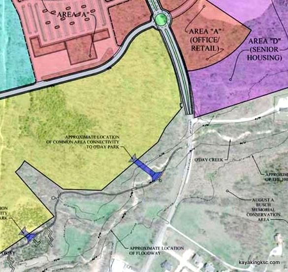
Streets of Caledonia and the new Highway DD traffic circle near the O'Day Creek
A traffic circle will be placed near the O'Day Creek. A traffic circle that the 12,000 daily users of Highway DD have no knowledge of its arrival and had no say in the road they use everyday.
A traffic circle that will bring the 55 mile an hour traffic to a near dead stop while they navigate a 15 mile an hour roundabout.
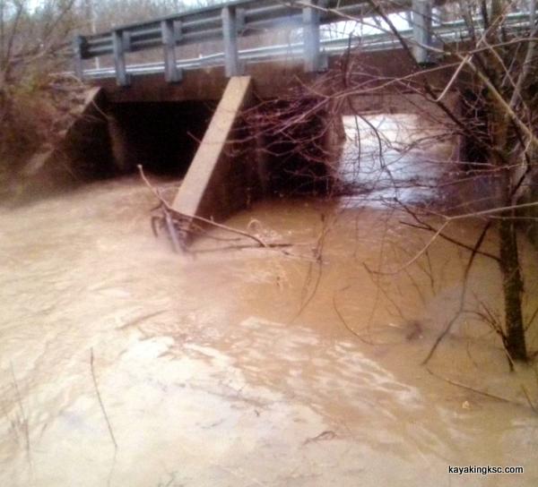
Highway DD Bridge.
The new traffic circle will not only dramatically lower traffic speeds, it will back rush hour traffic onto the old 1944 O'Day creek bridge that was condemned in 2018
(Photo was taken because of the flood waters caused by the O'Day Park)
The City Officials will blatantly (righteously) explain that the users of Highway DD from the back country "are not their citizens" and therefore the opinions of the people who live outside the City Limits or their traffic delays are not the concern of the City.
(The way I read that statement is the hicks out in the farmlands and wineries are not lining the pockets of the City Officials. The world after all does run on corruption.)
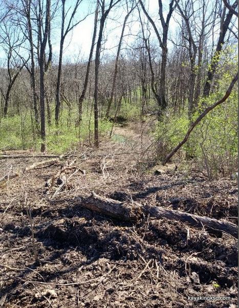
The Enchanted Forest.
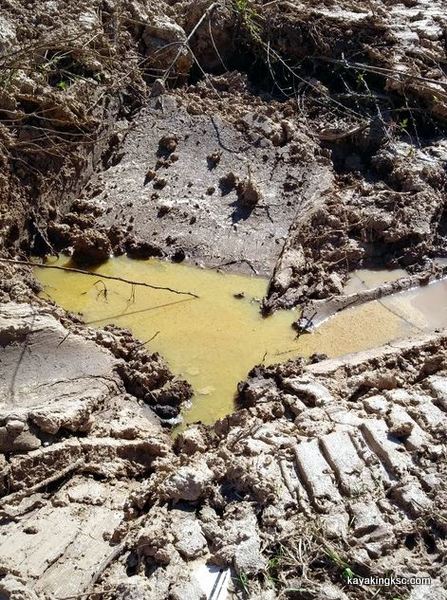
The price of developing the ridge above the ODay Creek. The tracks are from the equipment cutting down the trees.
At least they left some drinking water for the birds and animals. Of course this mud will flow what direction?
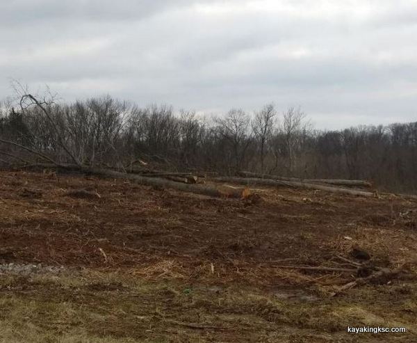
Truly hope everyone had a chance to hike and bird watch in the Enchanted Forest
The Enchanted Forest.
Well I am not anti development or anti housing development.
However I have to admit it is less painful to see the prime farmland get paved over than the destruction of the forests.
That farmland has been cleared for 150 years. Paving the farmland means people might starve but the animals were already gone and the watershed impaired.
The Enchanted Forest as it was known by the local hiker and backers was a series of ridges too steep to farm and was left for hardwood and walnuts.
The Land Bridge.
The Enchanted Forest was a land bridge/wildlife corridor for animals traveling between the 8000 acre Augusta Busch Wildlife Area and the O'Day Park.
Big hard wood buzzed out the Enchanted Forest. (Getting ready for the asphalt. However I know it will be pretty asphalt.)
Note I used the term "Was"
The developer with a little help from the City Council already had the loggers come in and cut as many trees as they could before the "Bat protection laws" kicked in March.
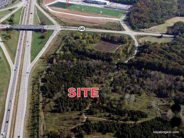
The last green space to be paved over. Location is the I-64/Hwy 40 Corridor straddling the east end of Highway DD
The Green Mile
60 acres of the LAST green to be clear cut of the old trees and asphalted over.
The plan is to build a Mixed-Use Development. And then "convince" the City of O'Fallon to change the zoning to put up high density apartments for a total of 600 residential homes and strip malls.
What makes this location any different than the thousands of other acres saturated with houses?
The location of Augusta Busch Wildlife Area.
The current location of the new Streets of Caledonia is a wildlife corridor between the 8000 acre wildlife area and the new Green O'Day Park.
The worst part of the story?
For a fraction of the cost to build and maintain the O'Day Park Lodge (a forever burden in operation costs) THE CITY COULD HAVE PURCHASED THE LAST 60 ACRES OF GREEN as a permanent wildlife corridor to Busch Wild life area. Forever, green space of biking and hiking trails that would have drawn nature lovers.
Why wasn't the land purchased for a park & wildlife corridor?
Lucrative contracts for land clearing, building material and new tiny trees to replace the old growth forests. That is only my speculation.
Any city father who actually cared for the lifestyle of their citizens would have worked to purchase the wildlife corridor.
After all the land for O'Day Park was free, but the citizens of O'Fallon passed a bond for a seven million raid on the taxpayers to develop the O'Day Park.
But the adjoining land now known as Streets of Caledonia?
"Streets of Gold" for the city fathers, and their chosen business partners.
The developers pay out the bribes for the politicians to create favorable rules; they think in long term projects. BIG money.
Easy example:
1. The eminent domain of lands to installed the buried sewage line on the west side of interstate 64 & both sides of HWY DD when there was not a need.
Someone was thinking "Streets of Gold" & used eminent domain.
2. O'Day Park. A $14 million bond passed to create a "Green Park" on already green forest.
3. Streets of Caledonia. 600 hundred new homes on the last Green Mile with 'connectors' to the O'Day Park that was not needed.
And during all projects? Lucrative contracts for land clearing, building material and new tiny trees to replace the old growth forests.
Another view that shows the houses surrounding the last Green
This is the last Green in O'Fallon's 30 year war on nature and their unholy alliance with uncontrolled developers.
The true scope of corruption lies in the fact that the City of O'Fallon just finished their so called "Green space" of pavement and lodge, concert venue and artificial sward.
Convincing the gullible tax payers of O'Fallon to fork over milliond was child's play to those officials steeped in the art of back room deals.
Instead the plan was all along to strip down the green space and add 600 more unnecessary homes
The more the citizens complain, the more money our "Leaders" get to request for their bribes to "Pave" the way for destruction of the landscape.
The developers know payout is the price of business & the city councils, the mayors and city fathers know they are only in office a short time
Life is good to be in bed with corruption & be dammed that that pesky foliage. Streets of Caledonia
This project could be a sterling example of the incestuous and parasitic relationship between our community "Leaders" and the developers of the endless housing developments that blight the land.
And of course very few care about the bats and homes for their pups.
Return HOME from the Streets of Caledonia

My next book!! "Surviving Kennedy Space Center"
on Amazon.
Peek behind the curtains of the Shuttle and Artemis programs.

(Second to newest) My newest book, available on Amazon
(paperback and e-book)
For pet lovers around the globe, "It's a Matter of Luck" is a collection of heart warming stories of horse rescues from the slaughterhouse.
Available on Amazon

It's a Matter of Luck: Inspirational, Heartfelt Stories of Horses Given a Second Chance.
by Kim Ryba & Lina T. Lindgren
Warning: This book may cause your eyes to water in a good way. (speaking from experience after reading it)
Please give Kim and Lina a heartfelt review on Amazon!

Author Bruce Ryba at Kennedy Space Center Launch Pad 39B & Artemis 1. "We are going to the Moon!"
Author's discussion (that's me) on You Tube of a book review on Amazon
For the video versions of information, please check out my YouTube Channel (Turkeys, Flintknapping, dive stories etc.)
My fictional series/stories on Florida history:
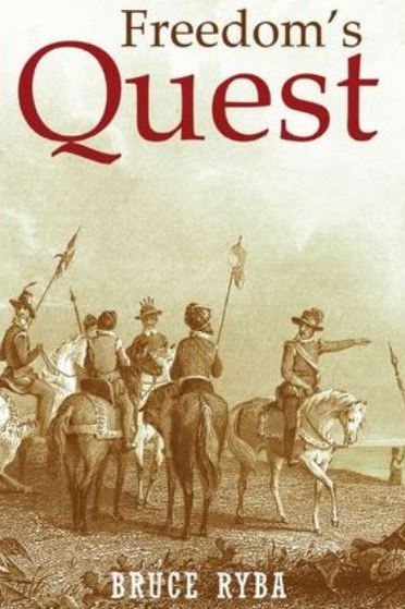
Freedoms Quest (book one)
Struggle for the northern frontier and other lost tales of old Florida.
Available on Amazon

Desperate times call for bold action.
In a desperate move to retain Florida and protect the treasure-laden galleons on their dangerous return journey to Europe, the King of Spain issues a royal decree offering refuge to all English slaves who escape Florida and pick up a musket to defend the coquina walls of Saint Augustine.
In another bold gamble, the King offers refuge to the dissatisfied Indian nations of the southeast who will take up arms against the English.
Clans, traumatized by war and disease, cross the Spanish Frontier to settle the cattle-rich land and burned missions of Florida.
Follow the descendants of the conquistador Louis Castillo in remote Spanish Florida, a wild and swept by diseases, hurricanes, and northern invasions.
Book Two: End of Empire Available on Amazon!